Running Kings Peak
While I have avoided formal running races so far this year I was still drawn to running iconic natural features of my surrounding area. Some of these locations include the internationally known Grand Canyon in a brutal rim-to-rim-to-rim single day ultra marathon. I might attempt this sometime in 2023 if I can maintain consistent training. Another nearby feature on my list was the highest peak in the state of Utah, Kings Peak. Name after Clarence King1, I am not sure if the title of the peak should be possessive or simply plural. Regardless, the long approach and high altitude makes this mountain formidable to digest in a single day.
The start of the most commonly used trail to get to Kings Peak is from Henry’s Fork trail head. Depending on your origin you might approach this location from the North or the West. A work colleague that lives in southern Salt Lake City told me they reached the trail head from the West by Highway 150 and then Forest Road 58, 73, 17, and finally 77. My source location was farther north so I arrived at the trail head from the North by passing through Evanston, Fort Bridger, Mountain View, Lonetree, and finally over Forest Road 77.
Sleep
There are camping sites at Henry’s Fork trail head and dispersed options abound but my last minute decision was to simply sleep in my car as close as possible to the trail head. I had actually re-mounted my roof top tent the day prior and planned on simply stealth sleeping in the parking lot. After arriving at about 10:30 PM I realized my gamble would be perfectly fine as I could see a number of converted sprinter vans in the parking lot with lights on inside and some moderate activity in the parking lot. It seemed mostly just bathroom visits as people were getting ready to go to sleep. In retrospect I assume this kind of parking lot camping was normal for these self-contained camper vans but it was pretty unfamiliar to me. After situating myself I quickly opened up my tent and went to bed with plans to get up at around 5:45 AM.
It was certainly my own idiocy for sleeping fifty feet from the trail head that funneled dozens of people from the civilized world of automobiles into the backpacking nirvana of the Northern Uintas. Feel free to dismiss this next section as the whining of someone that didn’t concern themselves with logical deduction. To be fair, I can understand people walking by in the noisy gravel parking lot, car doors opening or closing, or bathroom doors creaking, but I never expected to hear Led Zeppelin’s Black Dog at a quarter after two in the morning blasting from a newly arrived car just a few slots down. Staying true to my passive aggressive personality I simply chose to climb out my tent for a bathroom break in the hopes that they would see there were actual people sleeping nearby. Either this maneuver to the bathroom worked or my timing simply meshed with their bedtime and the music faded out.
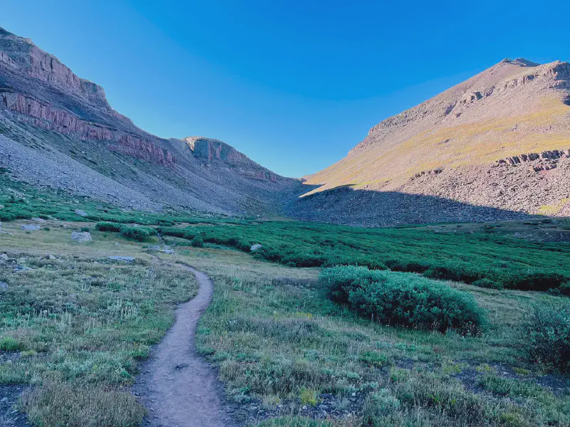
Early portion of Kings Peak Trail
The peace was short lived until a bit after 4 AM when this rock-n-roll car had their friends arrive to start their hike to celebrate a group member’s birthday. This was another oversight on my part because many people who do Kings Peak in a day start at about four or five in the morning in order to summit prior to afternoon thunderstorms. You would be safe to write off the hours of four to six in the morning near the trail head simply due to the traffic of people and cars. This might be relevant information to one such as myself who is notoriously lazy in the morning and sleeps as late as possible in all situations. While I realize most of these encounters are my own stupid fault it might bring some clarity to future travelers and their plans for attempting Kings Peak.
Morning Trail
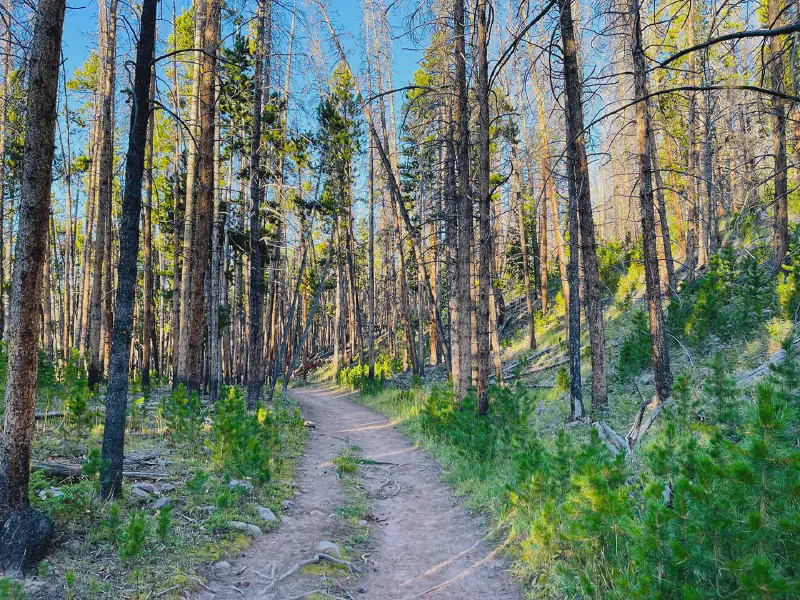
Dragged into consciousness in the dark and cold morning I finally got up and ready at a little past six. The morning temperature was brisk in the low forties yet the sky was beginning to lighten up with the rising sun. My starting time was at 6:50 and the elevation in the parking lot sat at approximately 9,446 feet. Much of the first six miles of the trail winds along the river over small foothills with scraggly rocks dotting the dirt path. These weren’t a problem in the morning when I was fresh but became a huge problem later on in the day when my legs were tired and my coordination lagged. My pace for this first portion varied between 12:08 to 14:14 minutes per mile. The terrain here is very forgiving to a slow jog and I only slowed down when it became too rocky.
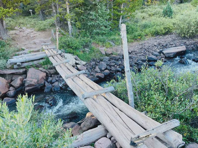
Henry’s Fork River makeshift bridge
At about the mid-point of mile five you cross over the river in an endearing bridge and the terrain starts to open up into high mountain meadows. The initial section of the run has a certain mountain beauty but is rather claustrophobic. It is only until you get higher up that you see the grandness of the Uintas’ alpine terrain. There aren’t any jagged snow covered peaks but the lack of trees and the unique rock gives it a very different appearance. My speed at this part of the run was slightly slower since I began to feel the impact of the higher altitude. It came in at around 12:44 to 18:46 minutes per mile.
Between mile seven and the first part of ten is a treasure trove of camping locations that backpackers gobbled up. Passing by them early in the morning as they were preparing breakfast and sitting by their campfires was very picturesque. I met a few on the trail that had camped in this area and I must admit it would be tempting to utilize the base camp method in the future. Halving the total distance of the trail would have made it immensely enjoyable. However, that would come at a slight cost of lugging all the required equipment up to said backpacking spot. In any case I think future attempts by me on this trail would either require additional training to make it easier to relying on a base camp to tamper down the physical toll.
Near Dollar Lake
My pacing decision in the morning ascent was overly aggressive. The thought process behind this mindset was that this was my yearly race and required a certain gusto to be invested in my effort. Such thinking was misplaced due to not resting my body over a week or two with a taper period. This is required in all training plans in order to push your body without injury. Additionally, my morning nutritional foundation was sorely lacking. In normal circumstances I consume a meal replacement shake (Huel) with approximately four to eight hundred calories about an hour before starting. This fueling method has proven critical for me in approaching long weekend runs with enough stamina to maintain a certain pace throughout. But I skipped this particular breakfast meal in the hopes of delaying bowel movement over the course of the day. The fear was that once above tree line there would be no source of privacy. This was pretty juvenile of me and should not have been a concern. It would have been much wiser to simply stay the course with my developed long run habits.
Shortcuts
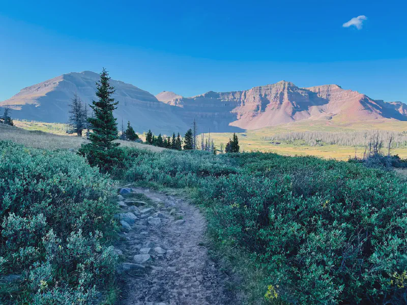
Towards the end of mile ten you approach the wide saddle of Gunsight Pass at about 11,881 feet. The slog up this steep section is just a preparatory portion to sort of wake you up from the rolling hills of the previous ten miles. Once at the top you can either take the normal Gunsight Trail or do a bit of cheating with the Dome Peak Cutoff Trail. I took the Dome Peak Cutoff trail as it stayed at the higher elevation as you taking the bend around Dome Peak. It doesn’t make sense to me to take Gunsight Trail back down in altitude to simply waste the calories you just burned ascending the saddle. There is a large caveat with taking the Cutoff Trail due to the rough, rocky, and steep terrain. The trail itself is also not specifically defined so I lost it several times myself. But overall, the shortcut saves you several miles and certainly several hundred feet of elevation loss and gain.
Approaching Gunsight Pass Saddle
Once around the bend of Dome Peak there is a shallow valley between yourself and the beginning of the Kings Peak summit. Some stick to the Cutoff Trail at the base of Dome Peak in an effort to maintain altitude as you approach the Toilet Bowl area. This is exactly what I did in my ascent but regret it in retrospect due to the extremely rocky nature of the path. It does indeed accomplish the goal of maintaining altitude since you basically stay at the same height of the Gunsight Pass saddle. But at mile 12 and with the summit shortly ahead it would be best to save your legs. A better path would be to descend slightly and cut across the least rocky part of the valley. It will take you down in altitude a bit but will save your legs from rock hopping along the valley edge. Once across the valley you can merge with the normal Uinta Highline Trail that is well defined and mostly rock free. Due to taking the rocky and steep path my pace continued to decline with the higher altitude at between 18:45 to 27:05 minutes per mile.
Rock Scree Ascension
After reaching the base of the summit I took a break since it was protected from the wind. There are spots along the spine trail that are shielded from the mountain winds but I wanted to keep my momentum all the way to the peak. As with other rocky parts of this area you can easily lose the trail because there is no way for a worn out pathway to develop. I relied heavily on taking chronic pauses to both catch my breath and also look around for the most logical footpath forward. The pausing approach to the ascent became invaluable with the rising altitude of the trail. It became very apparent after surpassing 11,200 feet while approaching the saddle and got worse with every step. In some segments I would over exert myself and a massive headache would ensue, as if I was holding my breath while running up a flight of stairs. In turn, I would take a quick break and the feeling would subside.
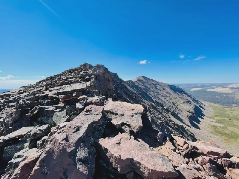
Endless rock scree on Kings Peak Ridge
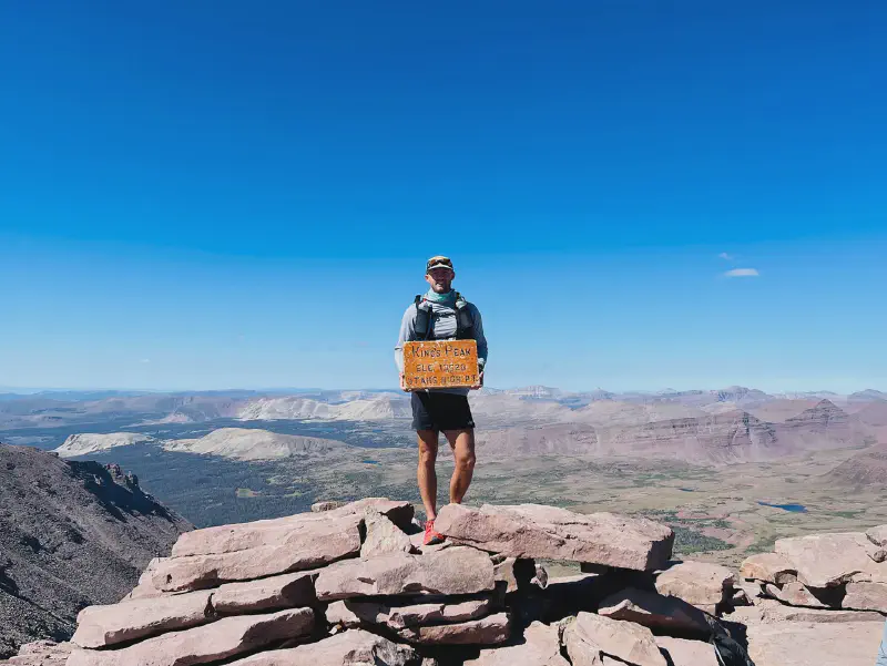
The final ascent of the summit was rather drawn out. The summit is quite far to the south from where you start on the spine and is misleading in perceived distance. My pace suffered greatly here with the rock hopping and the incredible altitude of 13,528 feet. It brought a resulting 33:55 to 50:53 minutes per mile from the twelfth and fifteenth mile. At the top the views were pretty grand in all directions. I was lucky enough to summit at a time when the weather was sunny, clear, and with only isolated gusts of wind. What amazed me most about the summit was the fact that the wooden hand held sign remained after so many years. I would imagine the peak is subject to extreme weather events on a regular basis and somehow it just sits there tucked away between some rocks.
The descent was an attempt at another shortcut, which failed. Rather than following the spine trail I tried to cut down the summit at an aggressive slope but was thwarted by an ocean of loose rocks and small boulders. My progress was slow and frustrating and I would consider this portion of the trail the most frustrating. If you go too fast you could easily fall and break a variety of things on your body. Not to mention the incredible distance away from civilization you are it near the summit and the resulting cost of medical rescue. Certainly much more prudent to take it slow and steady over the sea of rocks. For the descent miles before reaching the saddle I only managed a pace of approximately thirty minutes per mile.
Slow Descent
Following the descent of the Gunsight Pass saddle my pace picked back up again in an effort to achieve my goal time of seven hours from car to car. I was able to keep this last ounce of effort going between miles sixteen to nineteen at 10:07 to 14:57 minutes per mile. Towards the middle endpoint of this run it became very apparent that my legs and body were extremely exhausted. If I continued to attempt to run it would only be a matter of time before I would wipe out. The risk was due to the previously mentioned scraggly rocks dotting the path of the lower trail miles. Small sections would be bare dirt and would invite a slow easy jog without question. Yet these bundles of rocks would show up at a whim and create a dangerous area of uneven ground ripe for twisting an ankle or tripping me up. I can remember in about three instances where I rolled my ankle dangerously close to a serious injury due to an errant rock my tired legs couldn’t manage past.
The fear of injuring myself was the core reason for slowing down to a walk towards the twilight of this run. Yet there was another tier of exhaustion that followed afterwards. At about mile nineteen I hit a level of tiredness I only experience every few years. In this situation it was a combination of lack of calories, distance, altitude, and excessive rock hopping. It made everything seem monumental, such as walking over a small hill and the annoyance of trying to walk over rocky sections of the trail. In other ways it also brought to mind the incredible physical limits I had put my body through but in some degree of insanity it was still going. I didn’t find it pleasurable in any way but I certainly was amazed at the survival like stamina a person experiences towards the end of a hard physical activity. It is frequently amazing and is a great insight into your absolute physical limitations. Power walking the last few miles gave me a pace between miles 20 to 24.73 of between 16:22 to 20:14 minutes per mile.
I am pleased with my performance given that it was my first time to the area and my first time at semi-high altitude. I plan to visit the trail in the next year or two for another attempt. I would be very interested in seeing my performance after training with more altitude gains in my training runs and incorporating a really aggressive caloric intake throughout the run. I didn’t really feel pressured with water but I should have probably upped my intake over the course of the run, especially with the altitude factor.
Statistics
- Distance: 24.73 miles
- Moving Time: 8:01:45
- Elapsed Time: 8:38:09
- Pace: 19.28/mi
- Elevation Gain: 5,482 feet
- Calories: 3,284
- Humidity: 56%
- Wind Speed: 7.8 mi/h
- Wind Direction: SW
Food & Water
- 2 liters water in pack bladder
- 1.18 liters water in front bottles (40 ounces)
- 5 small packets of apple sauce
- 2 Kind bars
- 2 packets of Goldfish
- Saltstick electrolyte pills
Gear
- Ciele Hat
- REI Sahara Shade Hoodie
- Mountain Hardwear Crater Lake T-Shirt
- New Balance Core Impact Running Shorts
- Hoka Speedgoat Shoes
- Feetures Socks
- Body Glide
- Black Diamond Trekking Poles2
- Arc’Teryx Norvan 14 pack
- Ultimate Direction 20 ounce bottles
I didn’t actually use these the entire trip but probably should have. It is just that I don’t use them during my training runs. But it would be great to spread the effort from my legs to my upper body in steep ascent situations. ↩︎